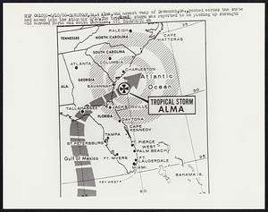
61. Alma,the newest vamp of Savannah,Ga.,pushed across the state and moved into the Atlantic 6/10.The tropical storm was reported to be picking up strength and menaced... Creator: United Press International Format: Photographs Collection: Boston Herald-Traveler Photo Morgue Date: [ca. June 1966] Institution: Boston Public Library
62. Alumni Hall Fundraising Map Format: Photographs Collection: College Archives Digital Collections Date: [November 15, 1928?] Institution: Springfield College Archives and Special Collections
63. Another world is possible : Midwest Social Forum Creator: Midwest Social Forum Format: Posters Collection: Stephen Lewis poster collection, circa 1921-2017 Date: 2006 Institution: University of Massachusetts Boston, Joseph P. Healey Library
64. Area Chart Creator: United States. Navy. Naval District, 1st Format: Photographs Collection: Photographs of the First Naval District Date: August 8, 1944 Institution: National Archives at Boston
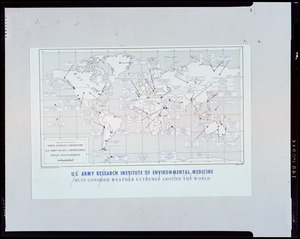
65. ARIEM map sites Format: Photographs Collection: Natick Soldier Systems Center Photographic Collection Date: [ca. 1970–1993] Institution: U.S. Army Natick Soldier Systems Center
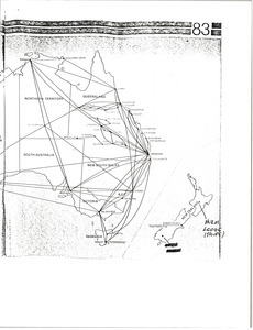
66. Australia and New Zealand map Format: Maps/Atlases; Manuscripts Collection: Mark H. McCormack Papers, ca. 1920-2008 (bulk: 1957-2003) Date: [ca. 1985] Institution: University of Massachusetts Amherst Libraries Special Collections and University Archives
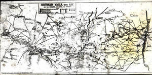
67. Australian Y.M.C.A. with A.I.F. (1918) Format: Photographs Collection: College Archives Digital Collections Date: 1918 Institution: Springfield College Archives and Special Collections
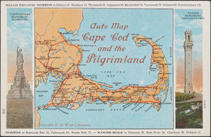
68. Auto map Cape Cod and pilgrimland Format: Postcards/Cards Collection: Historical Society of Old Yarmouth Archives and Local History Collection Date: [ca. 1850–2001] Institution: Historical Society of Old Yarmouth
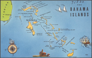
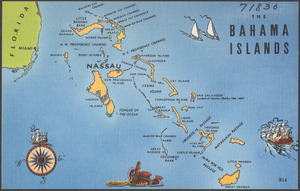
69. The Bahama Islands Format: Postcards/Cards Collection: Tichnor Brothers Postcard Collection Date: [ca. 1930–1945] Institution: Boston Public Library
70. The Bahama Islands Format: Postcards/Cards Collection: Tichnor Brothers Postcard Collection Date: [ca. 1930–1945] Institution: Boston Public Library
71. Barbara Garcia-Romero, Spanish Format: Photographs Collection: Pine Manor College Photograph Collection Date: November 1971 Institution: Pine Manor College
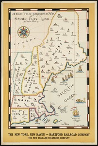
72. A beautifully engrossed map of summer play land Creator: Held, John, Jr., 1889-1958 Format: Posters; Prints Collection: Travel Posters Date: [ca. 1910–1959] Institution: Boston Public Library
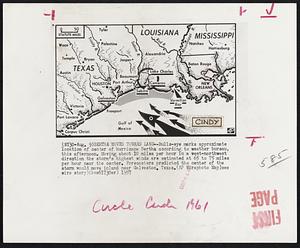
73. Bertha Moves Toward Land -- Bulls-eye marks approximate location of center of hurricane Bertha according to weather bureau, this afternoon. Moving about 10 miles per... Creator: Associated Press Format: Photographs Collection: Boston Herald-Traveler Photo Morgue Date: [ca. August 1957] Institution: Boston Public Library
74. Betsy. Format: Photographs Collection: Boston Herald-Traveler Photo Morgue Date: [ca. August 1965] Institution: Boston Public Library
75. Betsy. Format: Photographs Collection: Boston Herald-Traveler Photo Morgue Date: [ca. August 1955] Institution: Boston Public Library
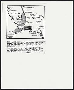
76. Betsy Hits Florida -- Hurricane Betsy slammed into southeast Florida today and the big calm eye moved over Key Largo, Betsy hurled 140-mile-an-hour gusts at the... Creator: Associated Press Format: Photographs Collection: Boston Herald-Traveler Photo Morgue Date: [ca. September 1965] Institution: Boston Public Library
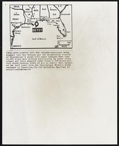
77. Betsy Hits New Orleans -- Hurricane Betsy slammed into New Orleans and the neighboring resorts of Mississippi’s plush Gulf coast tonight. More than 10,000 homes were... Creator: Associated Press Format: Photographs Collection: Boston Herald-Traveler Photo Morgue Date: [ca. September 1965] Institution: Boston Public Library
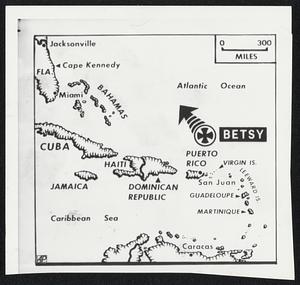
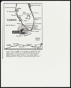
78. Betsy in Gulf -- Map locates current approximate position of Hurricane Betsy as it moves west of the Florida coast. Forecasters aren’t saying where it will hit next. Creator: Associated Press Format: Photographs Collection: Boston Herald-Traveler Photo Morgue Date: [ca. September 1965] Institution: Boston Public Library
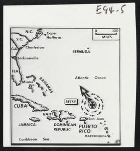
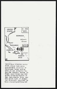
79. Betsy Moves West -- Cross indicates approximate location of Hurricane Betsy moving west in the Atlantic today. The Weather Bureau in Miami said Betsy was 260 miles... Creator: Associated Press Format: Photographs Collection: Boston Herald-Traveler Photo Morgue Date: [ca. September 1965] Institution: Boston Public Library
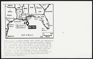
80. Betsy Nears Gulf Coast -- An emergency bulletin issued by the New Orleans weather bureau at 6 p.m., est, said the center of hurricane Betsy was located at about 150... Creator: Associated Press Format: Photographs Collection: Boston Herald-Traveler Photo Morgue Date: [ca. September 1965] Institution: Boston Public Library