Skip to search
Skip to main content
Skip to first result
Digital Commonwealth
Folders
Sign Up / Log In
Search for
Search
Search
Search
Basic
Advanced
Explore
Map
Collections
Institutions
Formats
For Educators
Primary Source Sets
Lesson Plans
Using Primary Sources
Searching Digital Commonwealth
For Institutions
Join Digital Commonwealth
Conferences, Trainings, & Events
How to Contribute Collections
Digitization Services
Board & Committees
Frequently Asked Questions
About
About Digital Commonwealth
News & Announcements
Copyright & Terms of Use
Harmful Content Statement
Partners
API
Contact Us
Search
Search Constraints
Start Over
Save Search
Your search:
More Like
commonwealth-oai:ww72bd325
✖
Remove constraint More Like: commonwealth-oai:ww72bd325
« Prev.
|
441
-
460
of
500
|
Next »
Sort
by relevance
relevance
title
date (asc)
date (desc)
recently added
Number of results to display per page
20
per page
per page
10
per page
20
per page
50
per page
100
per page
View results as:
List
list view
Maps
map view
Gallery
grid view
Search Results
441.
Plan of Cataumet Harbor in the towns of Bourne and Falmouth
442.
Plan of Charles River to the head of tide waters
443.
Plan of Chelsea Creek between East Boston and Chelsea exhibiting the circumscribing line to which wharves may be extended
444.
Plan of Cohasset Harbor
445.
Plan of Cotuit and Osterville Harbors
446.
Plan of Cuttyhunk Harbor and Pond in the town of Gosnold
447.
Plan of Cuttyhunk Harbor: in the town of Gosnold
448.
Plan of East Bay at Osterville in the town of Barnstable
449.
Plan of harbor at Cotuit and Osterville in the town of Barnstable: showing location of proposed channel from South Bay to...
450.
Plan of Island End River, Everett and Chelsea: under Chapter 106, Resolves of 1908
451.
Plan of Lewis Bay - Hyannis in the towns of Barnstable and Yarmouth
452.
Plan of main ship channel in Boston harbor: showing the work of removing certain obstructions to navigation
453.
Plan of Mount Tom and Mount Nonotuck: showing area suitable for a state reservation
454.
Plan of Mystic River
455.
Plan of new mouth of North River, Scituate: opened by storm of November 1898
456.
Plan of northerly portion of Boston Harbor: showing possible improvement of East Boston Flats
457.
Plan of part of Boston Harbor: showing improvements made in its channels
458.
Plan of part of Charles River: showing encroachments of bridge structures and physical changes in the river between U.S. Navy...
459.
Plan of part of Wareham River: in the town of Wareham
460.
Plan of Plum Island River in Newbury and Newburyport
« Previous
Next »
1
2
…
19
20
21
22
23
24
25
Limit your search
Subject
Massachusetts--Maps
285
Boston (Mass.)--Maps
61
Harbors--Massachusetts--Boston--Maps
59
Connecticut--Maps
47
Railroads--Massachusetts--Maps
40
Rhode Island--Maps
37
Massachusetts
32
Roads--Massachusetts--Maps
18
more
Subject
»
Place
North and Central America
500
United States
482
Massachusetts
474
Suffolk (county)
131
Boston
126
Connecticut
41
Rhode Island
37
Plymouth (county)
33
more
Place
»
Format
Maps/Atlases
454
Books
43
Manuscripts
4
Photographs
2
Prints
1
Available to use
No known restrictions
213
Creative Commons license
12
Date
View distribution
Current results range from
1762
to
2020
Date range begin
Date range end
View larger »
Unknown
3
Collection
Norman B. Leventhal Map & Education Center Collection
221
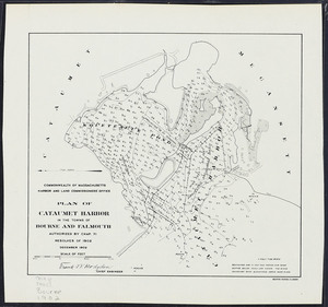
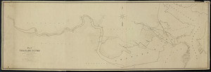
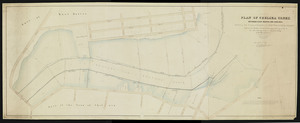
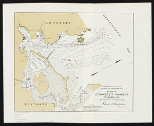
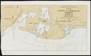
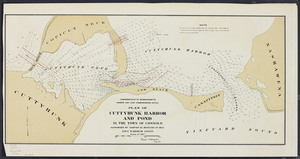
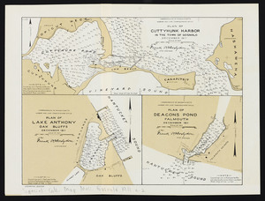
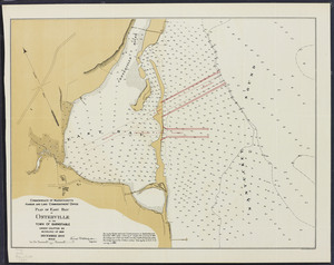
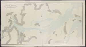
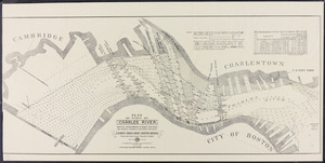
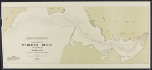
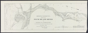
Massachusetts Board of Harbor and Land Commissioners
202
Boston and New England Maps (Collection of Distinction)
180
Historic Maps
33
Applied Geographics, Inc. Records
19
David Judkins Weaver Papers
19
American Revolutionary War-Era Maps (Collection of Distinction)
12
Urban Maps (Collection of Distinction)
11
more
Collection
»
Institution
State Library of Massachusetts
225
Boston Public Library
221
Salem State University Archives and Special Collections
33
American Antiquarian Society
8
Phillips Academy
8
Private Collection
3
Massachusetts Historical Society
1
Melrose Public Library
1