121. Map of Boston and the country adjacent, from actual surveys Format: Maps/Atlases Collection: Boston and New England Maps (Collection of Distinction) / Norman B. Leventhal Map & Education Center Collection Date: 1886 Institution: Boston Public Library
122. Map of Boston and the country adjacent, from actual surveys Creator: Walling, Henry Francis, 1825-1888 Format: Maps/Atlases Collection: Boston and New England Maps (Collection of Distinction) / Norman B. Leventhal Map & Education Center Collection Date: 1872 Institution: Boston Public Library
123. Map of Boston and the country adjacent, from actual surveys Creator: Walling, Henry Francis, 1825-1888 Format: Maps/Atlases Collection: Boston and New England Maps (Collection of Distinction) / Norman B. Leventhal Map & Education Center Collection Date: 1871 Institution: Boston Public Library
124. [Map of Boston and vicinity] Creator: American Society of Civil Engineers Format: Maps/Atlases Collection: Boston and New England Maps (Collection of Distinction) / Norman B. Leventhal Map & Education Center Collection Date: [1878] Institution: Boston Public Library
125. Map of Boston and vicinity : 1898 Creator: Geo. H. Walker & Co Format: Maps/Atlases Collection: Boston and New England Maps (Collection of Distinction) / Norman B. Leventhal Map & Education Center Collection / Urban Maps (Collection of Distinction) Date: [1898] Institution: Boston Public Library
126. Map of Boston and vicinity : 1895 Creator: Geo. H. Walker & Co Format: Maps/Atlases Collection: Boston and New England Maps (Collection of Distinction) / Norman B. Leventhal Map & Education Center Collection Date: [ca. 1895] Institution: Boston Public Library
127. [Map of Boston and vicinity] Creator: Walker, O. W. (Oscar W.) Format: Maps/Atlases Collection: Boston and New England Maps (Collection of Distinction) / Norman B. Leventhal Map & Education Center Collection Date: [ca. 1891] Institution: Boston Public Library
128. Map of Boston and vicinity including the metropolitan park system Format: Maps/Atlases Collection: Boston and New England Maps (Collection of Distinction) / Norman B. Leventhal Map & Education Center Collection / Urban Maps (Collection of Distinction) Date: 1894 Institution: Boston Public Library
129. Map of Boston and vicinity showing tracks operated by the Boston Elevated Railway Co., surface lines Format: Maps/Atlases Collection: Boston and New England Maps (Collection of Distinction) / Norman B. Leventhal Map & Education Center Collection / Urban Maps (Collection of Distinction) Date: 1898 Institution: Boston Public Library
130. A map of Boston, county of Suffolk and the adjacent towns Creator: Bowen, Abel, 1790-1850 Format: Maps/Atlases Collection: Boston and New England Maps (Collection of Distinction) / Norman B. Leventhal Map & Education Center Collection Date: [1830] Institution: Boston Public Library
131. Map of Boston Harbor Creator: Geo. H. Walker & Co Format: Maps/Atlases Collection: Boston and New England Maps (Collection of Distinction) / Norman B. Leventhal Map & Education Center Collection Date: 1899 Institution: Boston Public Library
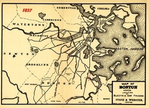
132. Map of Boston Showing the Location of Electric Car Tracks Creator: Stone & Webster Co Format: Maps/Atlases Collection: Historic Maps Date: 1898 Institution: Salem State University Archives and Special Collections
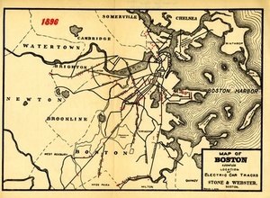
133. Map of Boston Showing the Location of Electric Car Tracks Creator: Stone & Webster Co Format: Maps/Atlases Collection: Historic Maps Date: 1898 Institution: Salem State University Archives and Special Collections
134. Map of Chelsea, Everett, Revere, & Winthrop Creator: Geo. H. Walker & Co Format: Maps/Atlases Collection: Boston and New England Maps (Collection of Distinction) / Norman B. Leventhal Map & Education Center Collection / Urban Maps (Collection of Distinction) Date: 1897 Institution: Boston Public Library
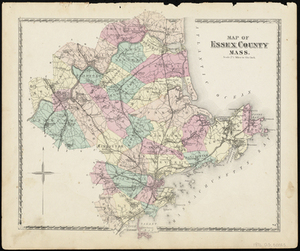
135. Map of Essex County Mass. Creator: D.G. Beers & Co Format: Maps/Atlases Collection: Historic Maps Date: 1872 Institution: Salem State University Archives and Special Collections
136. Map of Everett and vicinity Creator: Walker Lith. & Pub. Co Format: Maps/Atlases Collection: Norman B. Leventhal Map & Education Center Collection Date: 1906 Institution: Boston Public Library
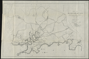
137. Map of Manchester, Mass. Format: Maps/Atlases Collection: Historic Maps Date: 1895 Institution: Salem State University Archives and Special Collections
138. Map of maneuver ground, Massachusetts, 1909 Creator: United States. Dept. of the Army. General Staff. . Second Section Format: Maps/Atlases Collection: Norman B. Leventhal Map & Education Center Collection Date: [1909] Institution: Boston Public Library
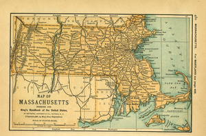
139. Map of Massachusetts Creator: Moses King Corporation Format: Maps/Atlases Collection: Historic Maps Date: 1891 Institution: Salem State University Archives and Special Collections
140. A map of Massachusetts Creator: Dunbar, Abigail S. Format: Maps/Atlases; Manuscripts Collection: Boston and New England Maps (Collection of Distinction) / Norman B. Leventhal Map & Education Center Collection Date: [ca. 1800–1820] Institution: Boston Public Library


![[Map of Boston and vicinity]](https://bpldcassets.blob.core.windows.net/derivatives/images/commonwealth:9s161d374/image_thumbnail_300.jpg)


![[Map of Boston and vicinity]](https://bpldcassets.blob.core.windows.net/derivatives/images/commonwealth:wd376691q/image_thumbnail_300.jpg)