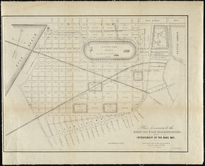
201. Plan Presented to the Honble the State Commissioners. For the Improvement of the Back Bay. Creator: Sears, David; Tappan & Bradford's Lith Format: Maps/Atlases Collection: Historic Maps Date: 1852 Institution: Salem State University Archives and Special Collections
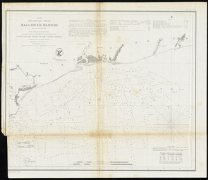
202. Preliminary Chart of Bass River Harbor Massachusetts Creator: United States Coast Survey, Bache, A. D., Eakin, C. M., Gluck, J. B., and McBliar, C. H. Format: Maps/Atlases Collection: Historic Maps Date: 1854 Institution: Salem State University Archives and Special Collections
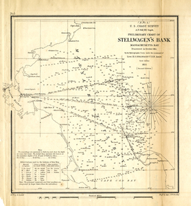
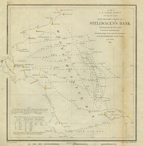
203. Preliminary Chart of Stellwagen's Bank, Masachusetts Bay: Discovered in October, 1854, by the Hydrographic Party Under the Command of Lieut. H. S. Stellwagen, U.S.N.,... Format: Maps/Atlases Collection: Historic Maps Date: 1855 Institution: Salem State University Archives and Special Collections
204. Preliminary Chart of Stellwagen's Bank, Massachusetts Bay Discovered in October, 1854, by the Hydrographic Party Under the Command of Lieut. H.S. Stellwagen, U.S.N.... Creator: United States Coast Survey, Bache, A. D., and Cordell, E. Format: Maps/Atlases Collection: Historic Maps Date: 1854 Institution: Salem State University Archives and Special Collections
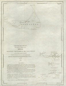
205. Preliminary Sketch Showing the Position of the Shoal Recently Discovered by the Coast Survey Creator: United States Coast Survey Format: Maps/Atlases Collection: Historic Maps Date: 1846 Institution: Salem State University Archives and Special Collections
206. Progress Map for 1893: Canapitsit Channel, Mass. From 1. July 1892 to 30 June 1893. Creator: United States Army Corps of Engineers, Brosig, Paul, Rostock, J. H., and Bixby, W. H. Format: Maps/Atlases Collection: Historic Maps Date: 1893 Institution: Salem State University Archives and Special Collections
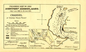
207. Progress Map for 1893, Westport Harbor, Mass.: From 1. July 1892 to 30. June 1893. Creator: United States Army Corps of Engineers, Brosig, Paul, Rostock, J. H., and Bixby, W. H. Format: Maps/Atlases Collection: Historic Maps Date: 1893 Institution: Salem State University Archives and Special Collections
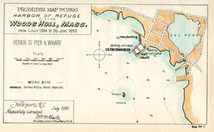
208. Progress Map for 1895, Harbor of Refuge Woods Holl, Mass.: from 1. July 1894 to 30. June 1895 Creator: United States Army Corps of Engineers, Brosig, Paul, and Harts, William Wright Format: Maps/Atlases Collection: Historic Maps Date: 1895 Institution: Salem State University Archives and Special Collections
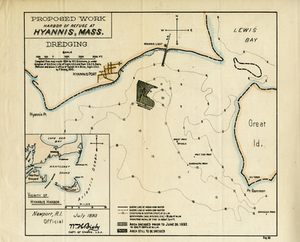
209. Proposed Work, Harbor of Refuge at Hyannis, Mass. Creator: United States Army Corps of Engineers, Brosig, Paul, and Simmons, W. C. Format: Maps/Atlases Collection: Historic Maps Date: 1893 Institution: Salem State University Archives and Special Collections
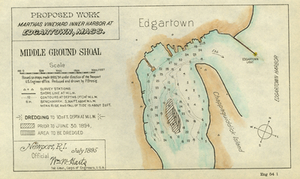
210. Proposed Work, Martha's Vineyard Inner Harbor at Edgartown, Mass.: Middle Ground Shoal Creator: United States Army Corps of Engineers, Brosig, Paul, and Harts, William W. Format: Maps/Atlases Collection: Historic Maps Date: 1895 Institution: Salem State University Archives and Special Collections
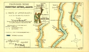
211. Proposed Work, Taunton River, Mass.: Parts of Upper River Creator: United State Army Corps of Englineers; Brosig, Paul Format: Maps/Atlases Collection: Historic Maps Date: 1895 Institution: Salem State University Archives and Special Collections
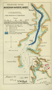
212. Proposed Work, Wareham, Mass. Creator: United States Army Corps of Engineers, Brosig, Paul, Simmons, W. C., and Rostock, J. H. Format: Maps/Atlases Collection: Historic Maps Date: 1893 Institution: Salem State University Archives and Special Collections
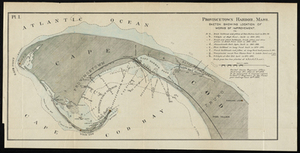
213. Provincetown Harbor, Mass. Creator: U.S. Engineer Office Format: Maps/Atlases Collection: Historic Maps Date: 1876 Institution: Salem State University Archives and Special Collections
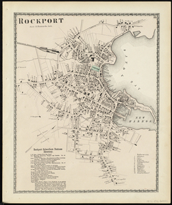
214. Rockport Creator: D.G. Beers & Co Format: Maps/Atlases Collection: Historic Maps Date: 1872 Institution: Salem State University Archives and Special Collections
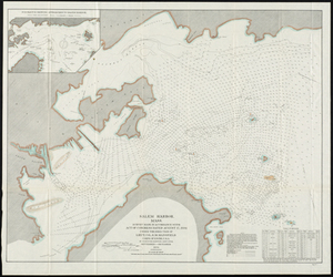
215. Salem Harbor, Mass. Survey Made in Accordance with Act of Congress Dated August 17, 1894 Creator: Mansfield, S M, Harwood, T.T. Hunter, and United State Army Corps of Engineers Format: Maps/Atlases Collection: Historic Maps Date: 1894 Institution: Salem State University Archives and Special Collections
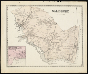
216. Salisbury Creator: D.G. Beers & Co Format: Maps/Atlases Collection: Historic Maps Date: 1872 Institution: Salem State University Archives and Special Collections
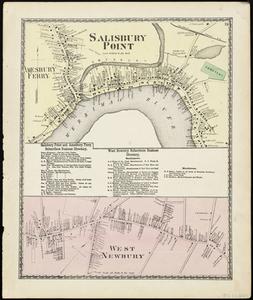
217. Salisbury Point Creator: D.G. Beers & Co Format: Maps/Atlases Collection: Historic Maps Date: 1872 Institution: Salem State University Archives and Special Collections
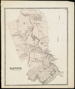
218. Saugus Creator: D.G. Beers & Co Format: Maps/Atlases Collection: Historic Maps Date: 1872 Institution: Salem State University Archives and Special Collections
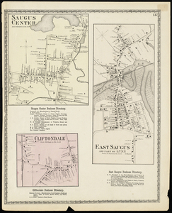
219. Saugus Center Creator: D.G. Beers & Co Format: Maps/Atlases Collection: Historic Maps Date: 1872 Institution: Salem State University Archives and Special Collections
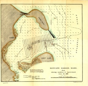
220. Scituate Harbor, Mass.: Plan Showing Condition of Improvement, June 30, 1886 Creator: United State Army Corps of Engineers Format: Maps/Atlases Collection: Historic Maps Date: 1886 Institution: Salem State University Archives and Special Collections