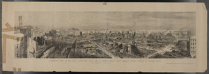
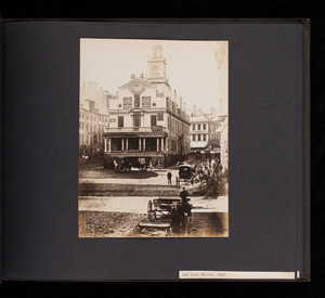
Skip to search
Skip to main content
Skip to first result
Digital Commonwealth
Folders
Sign Up / Log In
Search for
Search
Search
Search
Basic
Advanced
Explore
Map
Collections
Institutions
Formats
For Educators
Primary Source Sets
Lesson Plans
Using Primary Sources
Searching Digital Commonwealth
For Institutions
Join Digital Commonwealth
Conferences, Trainings, & Events
How to Contribute Collections
Digitization Services
Board & Committees
Frequently Asked Questions
About
About Digital Commonwealth
News & Announcements
Copyright & Terms of Use
Harmful Content Statement
Partners
API
Contact Us
Search
Search Constraints
Start Over
Save Search
Your search:
boston harbor ships
✖
Remove constraint boston harbor ships
Date
1865
to
1869
✖
Remove constraint Date: <span class="from" data-blrl-begin="1865">1865</span> to <span class="to" data-blrl-end="1869">1869</span>
« Prev.
|
121
-
140
of
377
|
Next »
Sort
by relevance
relevance
title
date (asc)
date (desc)
Number of results to display per page
20
per page
per page
10
per page
20
per page
50
per page
100
per page
View results as:
List
list view
Maps
map view
Gallery
grid view
Search Results
121.
The cargo landed, six great whales are seen lying on the dock at Spitzbergen, and another is visible in the harbor
122.
Boston Bay and approaches
123.
Fish Wharf, Boston, Mass.
124.
India Wharf and dock, Boston
125.
Boston, Massachusetts. Commercial Wharf, Atlantic Ave.
126.
Plan of Boston
127.
Boston, from State Street block, [illegible]
128.
Plan of Boston and its vicinity
129.
Steamboat - The City of Richmond - in Boston Harbour
130.
Plan showing new location of draws over Charles and Miller's Rivers: as determined by the Board of Harbor Commissioners, with...
131.
Sail loft in the Boston Naval Shipyard
132.
Plan no. 1 for the occupation of flats owned by the Commonwealth in Boston harbor: made under the direction of the Legislative...
133.
Plan of Boston and its Vicinity Prepared from the Best Authorities for the Boston Almanac
134.
Plan of Boston and its vicinity
135.
U.S.S. "Pennsylvania," U.S. Navy yard, Boston, Mass. Keel laid in 1865
136.
Comparative map of Cape Cod Harbor showing physical changes between the survey of Maj. J.D. Graham in 1835, and the U.S. Coast...
137.
Panoramic view of the ruins after the Great Fire in Boston
138.
Album 22: Boston Buildings and Streets, Part 1
139.
Album 23: Boston Buildings and Streets, Part 2
140.
John Currier, starting on maiden voyage, being towed out of the Merrimac to Boston
« Previous
Next »
1
2
3
4
5
6
7
8
9
10
11
…
18
19
Limit your search
Subject
Harbors
142
Ships
121
United States--History--Civil War, 1861-1865
110
Piers & wharves
84
Whaling
29
Boats
23
Rivers
23
Naval yards & naval stations
21
more
Subject
»
Place
North and Central America
297
United States
296
Massachusetts
185
Suffolk (county)
77
Boston
75
Virginia
71
Boston Harbor
39
Bristol (county)
36
more
Place
»
Format
Photographs
263
Maps/Atlases
41
Manuscripts
36
Prints
25
Letters/Correspondence
10
Drawings/Illustrations
6
Postcards/Cards
5
Ephemera
5
more
Format
»
Available to use
No known restrictions
151
Creative Commons license
81
Date
1865
to
1869
✖
[remove]
377
1865
to
1865
325
1866
to
1866
203
1867
to
1867
220
1868
to
1868
221
1869
to
1869
208
Current results range from
1671
to
2010
Date range begin
Date range end
View larger »
Collection
The Medford Historical Society Civil War Photograph Collection
78
Stereograph Collection
60
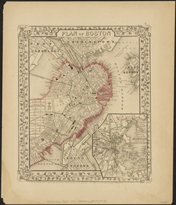
Norman B. Leventhal Map & Education Center Collection
25
Soldier's Record, Town of Chicopee
23
Charlestown Lantern Slides
20
Boston Pictorial Archive (Collection of Distinction)
18
Rotogravure Collection
18
Photograph Collection
16
more
Collection
»
Institution
Boston Public Library
166
The Medford Historical Society & Museum
78
New Bedford Free Public Library
44
Chicopee Public Library
23
Historic New England
19
State Library of Massachusetts
12
Boston College
6
The Trustees of Reservations, Archives & Research Center
6
more
Institution
»