Skip to search
Skip to main content
Digital Commonwealth
Sign Up / Log In
Search for
Search
Search
Search
Basic
Advanced
Explore
Map
Collections
Institutions
Formats
For Educators
Primary Source Sets
Lesson Plans
Using Primary Sources
Searching Digital Commonwealth
For Institutions
Join Digital Commonwealth
Conferences, Trainings, & Events
How to Contribute Collections
Digitization Services
Board & Committees
Frequently Asked Questions
About
About Digital Commonwealth
News & Announcements
Copyright & Terms of Use
Harmful Content Statement
Partners
API
Contact Us
Boston Public Library
Norman B. Leventhal Map & Education Center Collection
/
American Revolutionary War-Era Maps (Collection of Distinction)
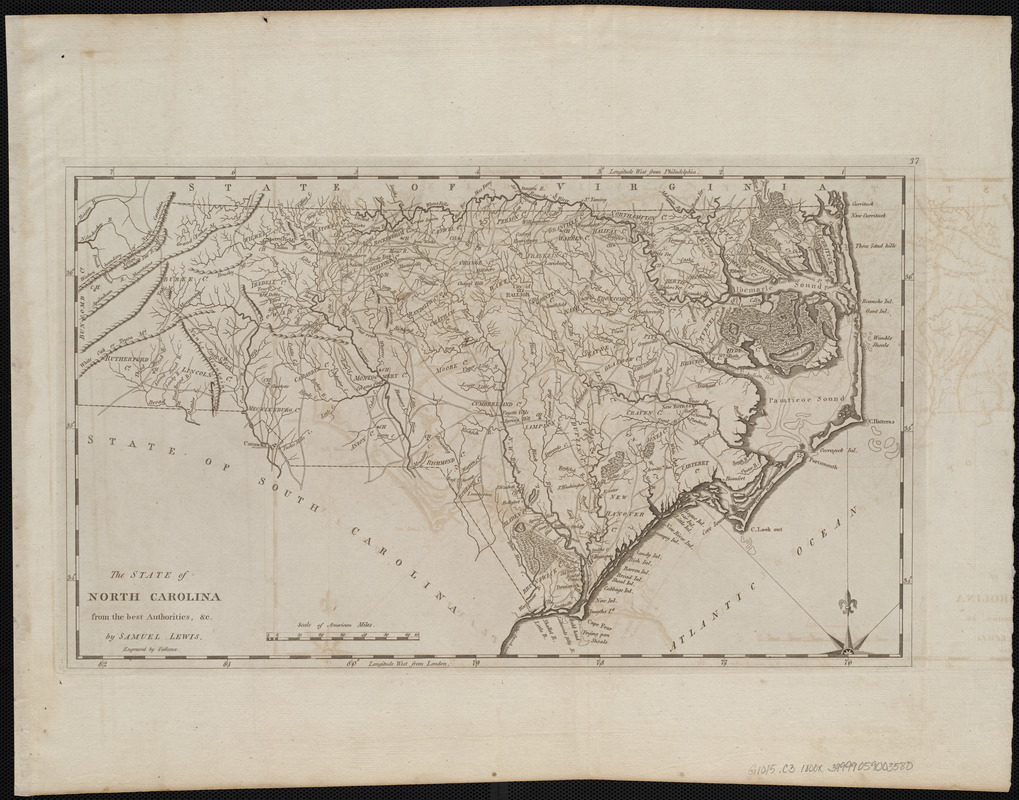
The state of North Carolina from the best authorities, &c
The state of North Carolina from the best authorities, &c
×
Item Information
Title:
The state of North Carolina from the best authorities, &c
Creator:
Lewis, Samuel, 1753 or 4-1822
Cartographer:
Lewis, Samuel, 1753 or 4-1822
Engraver:
Vallance, J. (John), 1770-1823
Publisher:
Carey, Mathew, 1760-1839
Name on Item:
by Samuel Lewis ; engraved by Vallance
Date:
[1800]
Format:
Maps/Atlases
Location:
Boston Public Library
Norman B. Leventhal Map & Education Center
Collection (local):
Norman B. Leventhal Map & Education Center Collection
Subjects:
North Carolina--Maps
Places:
North Carolina
Extent:
1 map ; 27 x 46 cm
Permalink:
https://ark.digitalcommonwealth.org/ark:/50959/3f463006d
Terms of Use:
No known copyright restrictions.
No known restrictions on use.
Publisher:
[Philadelphia] : [Mathew Carey]
Scale:
Scale approximately 1:1,330,000
Language:
English
Notes:
Relief shown pictorially.
Prime meridians: Philadelphia and London.
In upper right margin: 37.
Map 37 in his Carey's general atlas. Philadelphia : Mathew Carey, 1800.
Notes (date):
This date is inferred.
Identifier:
06_01_004556
Call #:
G1015 .C3 1800x
Barcode:
30000005056580
show more...
View MODS XML
More Like This
Coast of North Carolina & Virginia
Colton's new topographical map of the eastern portion of the State ...
Colton's new topographical map of the eastern portion of the State ...
Colton's North Carolina
Find More Like This >>
Tools
Share
Facebook
Pinterest
X
Reddit
Tumblr
Email
Copy link
Add to Folder
Questions/Comments
Cite This Item
IIIF Manifest
Downloads
Primary (full resolution, uncompressed)
(TIF, 55.3 MB)
Large (full resolution)
(JPEG, 4.64 MB)
Medium
(JPEG, 297 KB)
We'd love your feedback!
×
Would you be interested in taking a short survey about Digital Commonwealth?