Skip to search
Skip to main content
Digital Commonwealth
Sign Up / Log In
Search for
Search
Search
Search
Basic
Advanced
Explore
Map
Collections
Institutions
Formats
For Educators
Primary Source Sets
Lesson Plans
Using Primary Sources
Searching Digital Commonwealth
For Institutions
Join Digital Commonwealth
Conferences, Trainings, & Events
How to Contribute Collections
Digitization Services
Board & Committees
Frequently Asked Questions
About
About Digital Commonwealth
News & Announcements
Copyright & Terms of Use
Harmful Content Statement
Partners
API
Contact Us
Boston Public Library
Norman B. Leventhal Map & Education Center Collection
/
Urban Maps (Collection of Distinction)
/
Boston and New England Maps (Collection of Distinction)
/
Applied Geographics, Inc. Records
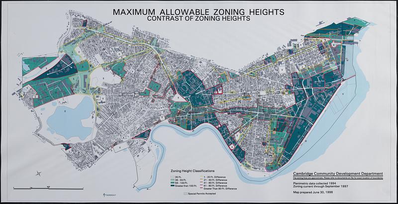
Maximum allowable zoning heights : contrast of zoning heights
Maximum allowable zoning heights
×
Item Information
Title:
Maximum allowable zoning heights : contrast of zoning heights
Cartographer:
Cambridge (Mass.). Community Development Department
Cartographer:
Applied Geographics, Inc.
Name on Item:
Cambridge Community Development Department ; Applied Geographics, Inc.
Date:
1998
Format:
Maps/Atlases
Location:
Boston Public Library
Norman B. Leventhal Map & Education Center
Collection (local):
Applied Geographics, Inc. Records
Subjects:
Cambridge (Mass.)--Maps
Buildings--Height restrictions--Massachusetts--Cambridge--Maps
Places:
Massachusetts
>
Middlesex (county)
>
Cambridge
Extent:
1 map : color, plastic-coated ; 57 x 111 cm
Permalink:
https://ark.digitalcommonwealth.org/ark:/50959/4j03k305k
Terms of Use:
No known copyright restrictions.
No known restrictions on use.
Publisher:
[Cambridge] : Cambridge Community Development Department
Scale:
Scale approximately 1:8,000
Language:
English
Notes:
Oriented with north to the left.
Also shows lots and buildings footprints.
"Zoning current through September 1997."
Identifier:
06_01_018994
Call #:
AppGeo Folder 5 no. 13
Barcode:
30000007789885
show more...
View MODS XML
More Like This
Sewerage division map city of Cambridge
Atlas of Middlesex County. Vol. 1. Cambridge, Somerville, ...
Atlas of the boundaries of the cities of Cambridge, Somerville, ...
Atlas of the city of Cambridge, Massachusetts
Find More Like This >>
Tools
Share
Facebook
Pinterest
X
Reddit
Tumblr
Email
Copy link
Add to Folder
Questions/Comments
Cite This Item
IIIF Manifest
Downloads
Primary (full resolution, uncompressed)
(TIF, 352 MB)
Large (full resolution)
(JPEG, 29.5 MB)
Medium
(JPEG, 90.3 KB)