Skip to search
Skip to main content
Digital Commonwealth
Sign Up / Log In
Search for
Search
Search
Search
Basic
Advanced
Explore
Map
Collections
Institutions
Formats
For Educators
Primary Source Sets
Lesson Plans
Using Primary Sources
Searching Digital Commonwealth
For Institutions
Join Digital Commonwealth
Conferences, Trainings, & Events
How to Contribute Collections
Digitization Services
Board & Committees
Frequently Asked Questions
About
About Digital Commonwealth
News & Announcements
Copyright & Terms of Use
Harmful Content Statement
Partners
API
Contact Us
Boston Public Library
Norman B. Leventhal Map & Education Center Collection
/
David Judkins Weaver Papers
/
Boston and New England Maps (Collection of Distinction)
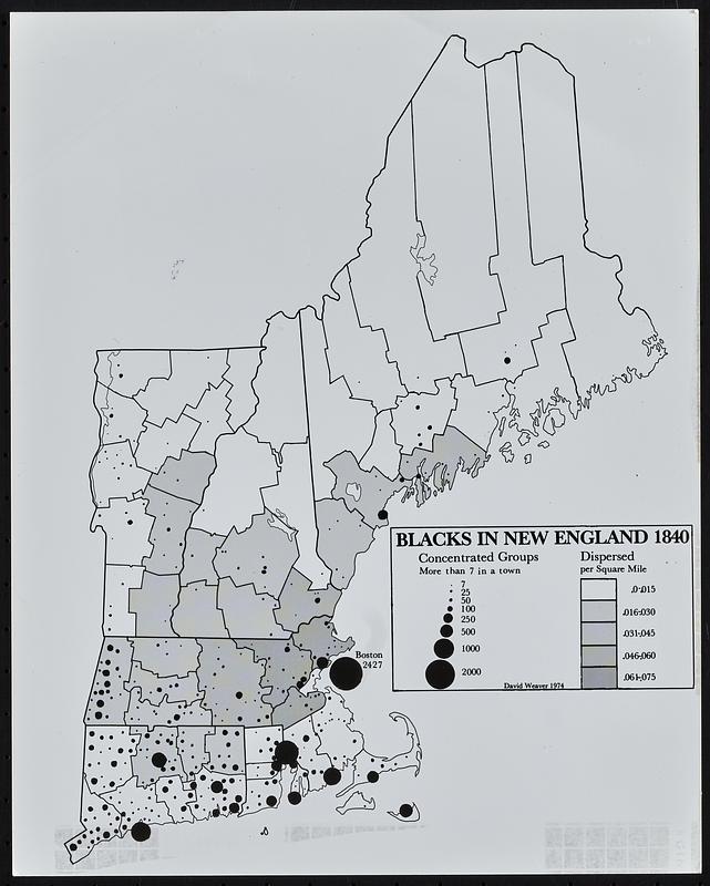
Black in New England 1840
Black in New England 1840
×
Item Information
Title:
Black in New England 1840
Cartographer:
Weaver, David Judkins, 1951-
Name on Item:
David Weaver
Date:
1974
Format:
Maps/Atlases
Location:
Boston Public Library
Norman B. Leventhal Map & Education Center
Collection (local):
David Judkins Weaver Papers
Subjects:
New England--Maps
African Americans--New England--Maps
Places:
New England
(area)
Extent:
1 map ; 26 x 21 cm
Permalink:
https://ark.digitalcommonwealth.org/ark:/50959/98811375p
Terms of Use:
No known copyright restrictions.
No known restrictions on use.
Publisher:
[Boston] : David Weaver
Language:
English
Notes:
Indicates number in a town and density by county.
Identifier:
06_01_018550
Call #:
Weaver folder 1 no. 3
show more...
View MODS XML
More Like This
New England fishery, recreation and scenic resources
New England regional transportation map = Mapa do transporte ...
ABC pathfinder railway guide map : eastern division
Atlas Maps of Massachusetts, Connecticut and Rhode Island, from ...
Find More Like This >>
Tools
Share
Facebook
Pinterest
X
Reddit
Tumblr
Email
Copy link
Add to Folder
Questions/Comments
Cite This Item
IIIF Manifest
Downloads
Primary (full resolution, uncompressed)
(TIF, 28.4 MB)
Large (full resolution)
(JPEG, 2.38 MB)
Medium
(JPEG, 90.2 KB)