Skip to search
Skip to main content
Digital Commonwealth
Sign Up / Log In
Search for
Search
Search
Search
Basic
Advanced
Explore
Map
Collections
Institutions
Formats
For Educators
Primary Source Sets
Lesson Plans
Using Primary Sources
Searching Digital Commonwealth
For Institutions
Join Digital Commonwealth
Conferences, Trainings, & Events
How to Contribute Collections
Digitization Services
Board & Committees
Frequently Asked Questions
About
About Digital Commonwealth
News & Announcements
Copyright & Terms of Use
Harmful Content Statement
Partners
API
Contact Us
Boston Public Library
Norman B. Leventhal Map & Education Center Collection
/
David Judkins Weaver Papers
/
Boston and New England Maps (Collection of Distinction)
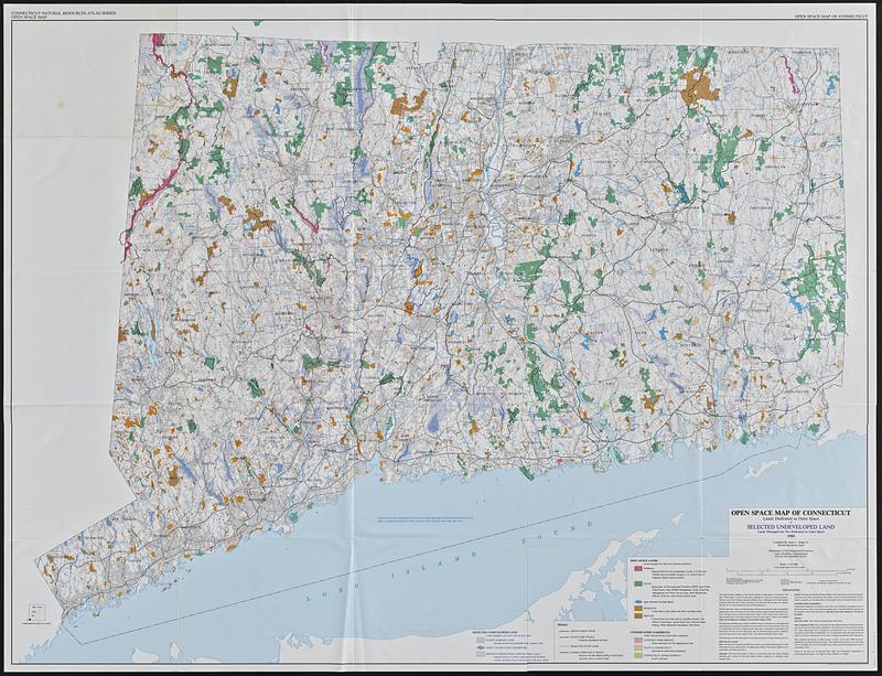
Open space map of Connecticut, lands dedicated as open space, and selected undeveloped land, lands managed but not dedicated as open space
Open space map of Connecticut, lands dedicated as open space, and selected undeveloped land, lands managed but not dedicated as open space
×
Item Information
Title:
Open space map of Connecticut, lands dedicated as open space, and selected undeveloped land, lands managed but not dedicated as open space
Title (alt.):
Selected undeveloped land, lands managed but not dedicated as open space
Cartographer:
Bogar, James C.
Contributor:
Connecticut. Natural Resources Center
Name on Item:
compiled by James C. Bogar Jr., Natural Resources Center
Date:
1990
Format:
Maps/Atlases
Location:
Boston Public Library
Norman B. Leventhal Map & Education Center
Collection (local):
David Judkins Weaver Papers
Subjects:
Connecticut--Maps
Open spaces--Connecticut--Maps
Trails--Connecticut--Maps
Recreation areas--Connecticut--Maps
Public lands--Connecticut--Maps
Places:
Connecticut
Extent:
1 map : color ; 103 x 137 cm
Permalink:
https://ark.digitalcommonwealth.org/ark:/50959/m326rf14p
Terms of Use:
No known copyright restrictions.
No known restrictions on use.
Publisher:
[Hartford], Connecticut||Capitol Heights, Md. : Department of Environmental Protection||Williams & Heintz Map Corporation
Scale:
Scale 1:125,000. 1 inch equals approximately 2 miles
Language:
English
Notes:
Relief shown by contours and spot heights.
"Contour interval 50 ft, national geodetic vertical datum of 1929."
"Base map prepared by Natural Resources Center, DEP, modified from USGS 1:125,000 scale base map of Connecticut, 1965 revised 1974."
Identifier:
06_01_018831
Call #:
Weaver folder 17 no. 8
show more...
View MODS XML
More Like This
Map of Connecticut
States of Massachusetts, Rhode Island and Connecticut : base map ...
States of Massachusetts, Rhode Island and Connecticut : base map ...
States of Massachusetts, Rhode Island and Connecticut : shaded relief
Find More Like This >>
Tools
Share
Facebook
Pinterest
X
Reddit
Tumblr
Email
Copy link
Add to Folder
Questions/Comments
Cite This Item
IIIF Manifest
Downloads
Primary (full resolution, uncompressed)
(TIF, 1010 MB)
Large (full resolution)
(JPEG, 84.5 MB)
Medium
(JPEG, 133 KB)