11201. Virginiae partis australis et Floridae partis orientalis, interjacentium[que] regionum nova descriptio Creator: Jansson, Jan, 1588-1664 Format: Maps/Atlases Collection: Norman B. Leventhal Map & Education Center Collection Date: [1639–1666] Institution: Boston Public Library
11202. A vision of Private Kutschkes of the German National Guard = Traumgebild des deutschen Landwehrmanns Kutschke! Creator: Government Loan Organization. Second Federal Reserve District. Liberty Loan Committee Format: Maps/Atlases Collection: Norman B. Leventhal Map & Education Center Collection Date: [ca. 1917–1918] Institution: Boston Public Library
11203. Vltoniae orientalis : pars Creator: Mercator, Gerhard, 1512-1594 Format: Maps/Atlases Collection: Norman B. Leventhal Map & Education Center Collection Date: [1628–1633] Institution: Boston Public Library
11204. Vmbria overo ducato di Spoleto Creator: Blaeu, Joan, 1596-1673 Format: Maps/Atlases Collection: Norman B. Leventhal Map & Education Center Collection Date: [1662?] Institution: Boston Public Library
11205. Völker und sprachen-karte von Deutschland und den nachbarländern im j. 1867 Creator: Kiepert, Heinrich, 1818-1899; Reimer, Dietrich, 1818-1899 Format: Maps/Atlases Collection: Norman B. Leventhal Map & Education Center Collection Date: 1867 Institution: Boston Public Library
11206. Volunteer militia and eastern army guide : One hundred and fifty miles around Richmond Creator: Magnus, Charles. Format: Maps/Atlases Collection: Norman B. Leventhal Map & Education Center Collection Date: [1861?] Institution: Boston Public Library
11207. Vom Rhein bis Paris Creator: Kiepert, Heinrich, 1818-1899; Reimer, Dietrich, 1818-1899 Format: Maps/Atlases Collection: Norman B. Leventhal Map & Education Center Collection Date: 1870 Institution: Boston Public Library
11208. Vorstellung einiger Gegenden und Plaetze in Nord-America unter Franzoesisch und Englische Jurisdiction gehoerig Creator: Homann Erben (Firm) Format: Maps/Atlases Collection: American Revolutionary War-Era Maps (Collection of Distinction) / Norman B. Leventhal Map & Education Center Collection / Urban Maps (Collection of Distinction) Date: 1756 Institution: Boston Public Library
11209. Vtriusque Castellae nova descriptio Creator: Blaeu, Joan, 1596-1673 Format: Maps/Atlases Collection: Norman B. Leventhal Map & Education Center Collection Date: [1635?] Institution: Boston Public Library
11210. La vue a vol d'oiseau de l'Abbaye de Saint-Martin de Laon (de l'Ordre de Prémontré) Creator: Gomart, Charles. Format: Maps/Atlases Collection: Norman B. Leventhal Map & Education Center Collection Date: 1868 Institution: Boston Public Library
11211. Vue de Quebec, capitale du Canada Creator: Le Rouge, Georges-Louis. Format: Maps/Atlases Collection: American Revolutionary War-Era Maps (Collection of Distinction) / Norman B. Leventhal Map & Education Center Collection Date: [1755] Institution: Boston Public Library
11212. Vue du Port-au-Prince et ses environs Format: Maps/Atlases Collection: American Revolutionary War-Era Maps (Collection of Distinction) / Norman B. Leventhal Map & Education Center Collection / Urban Maps (Collection of Distinction) Date: 1800 Institution: Boston Public Library
11213. W. & A.K. Johnston's map to illustrate the Chinese question Creator: W. & A.K. Johnston Limited Format: Maps/Atlases Collection: Norman B. Leventhal Map & Education Center Collection Date: 1898 Institution: Boston Public Library
11214. W. & A.K. Johnston's maps to illustrate the Niger and Upper Nile questions Creator: W. & A.K. Johnston Limited Format: Maps/Atlases Collection: Norman B. Leventhal Map & Education Center Collection Date: 1898 Institution: Boston Public Library
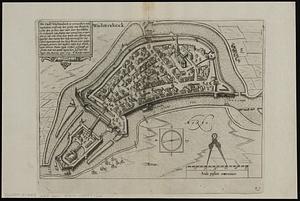
11215. Wachtendonck Creator: Keere, Pieter van den, 1571-approximately 1646, Jansson, Jan, 1588-1664, and Guicciardini, Lodovico, 1521-1589 Format: Maps/Atlases Collection: Norman B. Leventhal Map & Education Center Collection / Urban Maps (Collection of Distinction) Date: [1625] Institution: Boston Public Library
11216. Wage map no. 1 - Polk Street to Twelfth, Halsted Street to Jefferson, Chicago ; Wage map no. 2 - Polk Street to Twelfth, Jefferson Street to Beach, Chicago Creator: Greeley, Samuel S., Hull-House (Chicago, Ill.), Greeley-Carlson Company, and Thomas Y. Crowell Company Format: Maps/Atlases Collection: Norman B. Leventhal Map & Education Center Collection / Urban Maps (Collection of Distinction) Date: [1895] Institution: Boston Public Library
11217. Wage map no. 3 - Polk Street to Twelfth, Beach Street to Pacific Avenue, Chicago ; Wage map no. 4 - Polk Street to Twelfth, Pacific Avenue to State Street, Chicago Creator: Greeley, Samuel S., Hull-House (Chicago, Ill.), Greeley-Carlson Company, and Thomas Y. Crowell Company Format: Maps/Atlases Collection: Norman B. Leventhal Map & Education Center Collection / Urban Maps (Collection of Distinction) Date: [1895] Institution: Boston Public Library
11218. Wahre Bildtnüé der vesten Statt Montavban und wie dieselbe von Königl. Maÿ. in Franckreich belägert worden Anno 1621 Creator: Merian, Matthaeus, 1593-1650 Format: Maps/Atlases Collection: Norman B. Leventhal Map & Education Center Collection Date: [1635] Institution: Boston Public Library
11219. Wakefield and Peace Dale, Rhode Island : 1888 Creator: O.H. Bailey & Co Format: Maps/Atlases Collection: Boston and New England Maps (Collection of Distinction) / Norman B. Leventhal Map & Education Center Collection / Urban Maps (Collection of Distinction) Date: 1888 Institution: Boston Public Library
11220. Wakefield, Massachusetts : diagram showing the first ten miles of the Boston & Maine Railroad Creator: Eaton, J. S.; Sargent & Lawrence Format: Maps/Atlases Collection: Boston and New England Maps (Collection of Distinction) / Norman B. Leventhal Map & Education Center Collection / Urban Maps (Collection of Distinction) Date: [1870?] Institution: Boston Public Library
![Virginiae partis australis et Floridae partis orientalis, interjacentium[que] regionum nova descriptio](https://bpldcassets.blob.core.windows.net/derivatives/images/commonwealth:6t053p120/image_thumbnail_300.jpg)