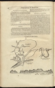
4581. A draft of the Golden & adjacent Islands, with part of ye Isthmus of Darien as it was taken by Capt. Ienefer where ye Scots West-India Company were setteled Creator: Senex, John, d. 1740 Format: Maps/Atlases Collection: Norman B. Leventhal Map & Education Center Collection Date: [1721] Institution: Boston Public Library
4582. Drake's silver map : British Museum Format: Maps/Atlases Collection: Norman B. Leventhal Map & Education Center Collection Date: 1923 Institution: Boston Public Library
4583. A draught of Boston Harbor by Capt. Cyprian Southake Creator: Southack, Cyprian, 1662-1745 Format: Maps/Atlases; Manuscripts Collection: Boston and New England Maps (Collection of Distinction) / Norman B. Leventhal Map & Education Center Collection Date: [1694] Institution: Boston Public Library
4584. A draught of New York from the Hook to New York Town Creator: Tiddeman, Mark. Format: Maps/Atlases Collection: Maritime Charts and Atlases (Collection of Distinction) / Norman B. Leventhal Map & Education Center Collection Date: [1737] Institution: Boston Public Library
4585. A draught of St. John's harbour : with the soundings Format: Maps/Atlases Collection: Norman B. Leventhal Map & Education Center Collection Date: [1900–1999] Institution: Boston Public Library
4586. A draught of the Bay of Honda Format: Maps/Atlases Collection: Maritime Charts and Atlases (Collection of Distinction) / Norman B. Leventhal Map & Education Center Collection Date: [1737] Institution: Boston Public Library
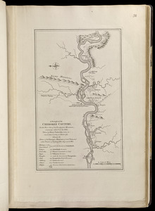
4587. A draught of the Cherokee Country, on the west side of the Twenty Four Mountains, commonly called Over the Hills Creator: Timberlake, Henry, -1765, Jefferys, Thomas, -1771, and Sayer, Robert, 1725-1794 Format: Maps/Atlases Collection: Norman B. Leventhal Map & Education Center Collection Date: [1768] Institution: Boston Public Library
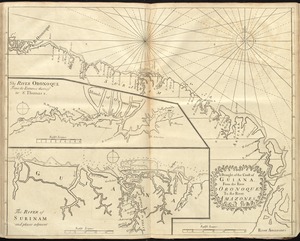
4588. A draught of the coast of Guiana, from the river Oronoque to the river Amazones Format: Maps/Atlases Collection: Maritime Charts and Atlases (Collection of Distinction) / Norman B. Leventhal Map & Education Center Collection Date: [1737] Institution: Boston Public Library
4589. A draught of the harbour of Hallifax and the adjacent coast in Nova Scotia Creator: Cook, James, active 1762-1775 Format: Maps/Atlases Collection: American Revolutionary War-Era Maps (Collection of Distinction) / Norman B. Leventhal Map & Education Center Collection Date: 1766 Institution: Boston Public Library
4590. A draught of Virginia from the Capes to York in York River and to Kuiquotan or Hamton in James River Creator: Tiddeman, Mark. Format: Maps/Atlases Collection: Maritime Charts and Atlases (Collection of Distinction) / Norman B. Leventhal Map & Education Center Collection Date: [1737] Institution: Boston Public Library
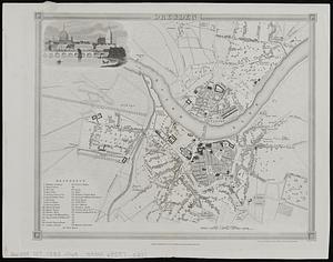
4591. Dresden Creator: Dower, John, active 1838-1846?; Orr & Smith Format: Maps/Atlases Collection: Norman B. Leventhal Map & Education Center Collection / Urban Maps (Collection of Distinction) Date: [ca. 1838–1846] Institution: Boston Public Library
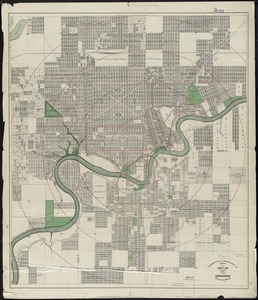
4592. Driscoll & Knight's map of the City of Edmonton, Province of Alberta Creator: Driscoll & Knight Format: Maps/Atlases Collection: Norman B. Leventhal Map & Education Center Collection Date: [1912] Institution: Boston Public Library
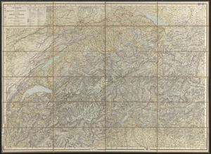
4593. Dritte karte der Schweiz = Troisième carte de la Suisse = Terza carta della Suizzera Creator: Ziegler, J. M. (Jakob Melchior), 1801-1883; Wurster, Randegger & Cie. Format: Maps/Atlases Collection: Norman B. Leventhal Map & Education Center Collection Date: [1860?–1869?] Institution: Boston Public Library
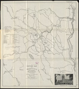
4594. Driving map of Woodstock & vicinity, Vermont Creator: Dana, E. C. Format: Maps/Atlases Collection: Boston and New England Maps (Collection of Distinction) / Norman B. Leventhal Map & Education Center Collection Date: [ca. 1896] Institution: Boston Public Library
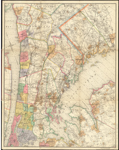
4595. Driving road chart of the country surrounding New York City : embracing the counties (or portions thereof) of New York, Kings, Queens, Westchester, Richmond, Rockland... Creator: Hyde & Company, Bracher, Wm. (William), and Goldthwaite, Wm. M. (William M.) Format: Maps/Atlases Collection: Norman B. Leventhal Map & Education Center Collection Date: 1890 Institution: Boston Public Library
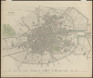
4596. Dublin Creator: Clarke, W. B., Turrell, Edmund, Baldwin & Cradock, and Society for the Diffusion of Useful Knowledge (Great Britain) Format: Maps/Atlases Collection: Norman B. Leventhal Map & Education Center Collection / Urban Maps (Collection of Distinction) Date: 1836 Institution: Boston Public Library
4597. Dublin Creator: Great Britain. Directorate of Military Survey Format: Maps/Atlases Collection: Norman B. Leventhal Map & Education Center Collection Date: 1956 Institution: Boston Public Library
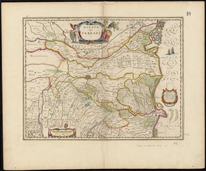
4598. Ducato di Ferrara Creator: Blaeu, Joan, 1596-1673 Format: Maps/Atlases Collection: Norman B. Leventhal Map & Education Center Collection Date: [1647] Institution: Boston Public Library
4599. Ducatus Angolismensis = Le Duche d'Angovlesme Creator: Jansson, Jan, 1588-1664 Format: Maps/Atlases Collection: Norman B. Leventhal Map & Education Center Collection Date: [1675] Institution: Boston Public Library
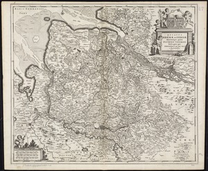
4600. Ducatus Bremae & Ferdae maximaque partis fluminis Visurgis descriptio Creator: Wit, Frederik de. Format: Maps/Atlases Collection: Norman B. Leventhal Map & Education Center Collection Date: [1680?] Institution: Boston Public Library