Skip to search
Skip to main content
Skip to first result
Digital Commonwealth
Folders
Sign Up / Log In
Search for
Search
Search
Search
Basic
Advanced
Explore
Map
Collections
Institutions
Formats
For Educators
Primary Source Sets
Lesson Plans
Using Primary Sources
Searching Digital Commonwealth
For Institutions
Join Digital Commonwealth
Conferences, Trainings, & Events
How to Contribute Collections
Digitization Services
Board & Committees
Frequently Asked Questions
About
About Digital Commonwealth
News & Announcements
Copyright & Terms of Use
Harmful Content Statement
Partners
API
Contact Us
Search
Search Constraints
Start Over
Save Search
Your search:
More Like
commonwealth:d791xv38q
✖
Remove constraint More Like: commonwealth:d791xv38q
« Prev.
|
21
-
40
of
145
|
Next »
Sort
by relevance
relevance
title
date (asc)
date (desc)
recently added
Number of results to display per page
20
per page
per page
10
per page
20
per page
50
per page
100
per page
View results as:
List
list view
Maps
map view
Gallery
grid view
Search Results
21.
Forbes' new and complete map of Richmond and its fortifications
22.
Frank Leslie's war maps and companion to the newspaper
23.
H.H. Lloyd & Co's campaign military charts showing the principal strategic places of interest
24.
Historical sketch of the rebellion
25.
The historical war map
26.
J.H. Colton's Topographical map of seat of war in Virginia, Maryland, &c
27.
Lloyd's new county map of the United States and Canadas showing battle fields, railroads, &c., compiled from the latest...
28.
Lloyd's new military map of the border & southern states
29.
Lloyd's new military map of the border & southern states
30.
Lloyd's new military map of the border & southern states
31.
Map illustrating the military operations in front of Atlanta, Ga : from the passage of Peach Tree Creek, July 19th, 1864, to...
32.
Map of Andersonville, Sumter Co., Georgia
33.
Map of southeastern portion of United States showing the location of battles in the Civil War 1861-1865
34.
Map of the seat of war : to accompany the American Conflict
35.
Map of the seat of war : containing a map of the vicinity of Washington, Baltimore, Harper's Ferry and Annapolis, with five...
36.
Map of the Southern States, showing the relative proportion of slaves in the different localities
37.
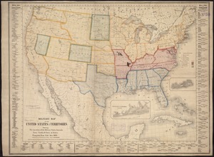
Military map of the middle and southern states showing the seat of war during the great rebellion in 1861
38.
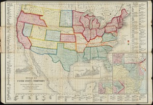
Military map of the United States & territories showing the location of the military posts, arsenals, Navy yards, & ports of...
39.
Military map of the United States & territories showing the location of the military posts, arsenals, Navy Yards, & ports of...
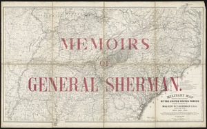
40.
Military map showing the marches of the United States forces under command of Maj. Genl. W.T. Sherman, U.S.A. during the years...
« Previous
Next »
1
2
3
4
5
6
7
8
Limit your search
Subject
United States--History--Civil War, 1861-1865--Maps
55
Massachusetts--Maps
17
Virginia--History--Civil War, 1861-1865--Maps
11
Confederate States of America--History--Maps
9
Land use--Massachusetts--Maps
7
Connecticut--Maps
5
Watersheds--Massachusetts--Maps
5
Boston Metropolitan Area (Mass.)--Maps
4
more
Subject
»
Place
North and Central America
130
United States
129
Massachusetts
53
Virginia
25
Confederate States of America
9
Boston
8
Suffolk (county)
8
Richmond
6
more
Place
»
Format
Maps/Atlases
141
Documents
2
Ephemera
2
Manuscripts
1
Posters
1
Available to use
No known restrictions
143
Date
View distribution
Current results range from
1860
to
2015
Date range begin
Date range end
View larger »
Collection
Norman B. Leventhal Map & Education Center Collection
143
David Judkins Weaver Papers
96
Boston and New England Maps (Collection of Distinction)
61
Urban Maps (Collection of Distinction)
7
American Civil War Collection
1
Other
1
Institution
Boston Public Library
143
Scottish Rite Masonic Museum and Library
1
State Library of Massachusetts
1
We'd love your feedback!
×
Would you be interested in taking a short survey about Digital Commonwealth?