Skip to search
Skip to main content
Digital Commonwealth
Sign Up / Log In
Search for
Search
Search
Search
Basic
Advanced
Explore
Map
Collections
Institutions
Formats
For Educators
Primary Source Sets
Lesson Plans
Using Primary Sources
Searching Digital Commonwealth
For Institutions
Join Digital Commonwealth
Conferences, Trainings, & Events
How to Contribute Collections
Digitization Services
Board & Committees
Frequently Asked Questions
About
About Digital Commonwealth
News & Announcements
Copyright & Terms of Use
Harmful Content Statement
Partners
API
Contact Us
Boston Public Library
Norman B. Leventhal Map & Education Center Collection
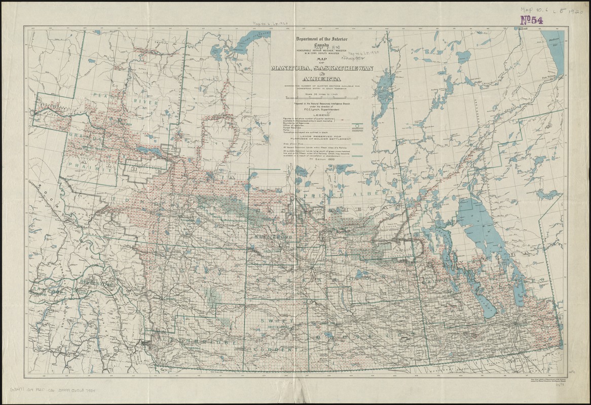
Map of Manitoba, Saskatchewan and Alberta : showing the number of quarter sections available for homestead entry in each township
Map of Manitoba, Saskatchewan and Alberta
×
Item Information
Title:
Map of Manitoba, Saskatchewan and Alberta : showing the number of quarter sections available for homestead entry in each township
Creator:
Canada. Natural Resources Intelligence Branch
Name on Item:
prepared in the Natural Resources Intelligence Branch under the direction of F.C.C. Lynch, Superintendent.
Date:
1920
Format:
Maps/Atlases
Location:
Boston Public Library
Norman B. Leventhal Map & Education Center
Collection (local):
Norman B. Leventhal Map & Education Center Collection
Subjects:
Land use--Prairie Provinces--Maps
Homestead law--Prairie Provinces--Maps
Prairie Provinces--Maps
Places:
Canada
>
Prairies
(area)
Extent:
1 map : col. ; 53 x 82 cm.
Permalink:
https://ark.digitalcommonwealth.org/ark:/50959/4m90ff741
Terms of Use:
No known copyright restrictions.
No known restrictions on use.
Publisher:
[Ottawa] : Dept. of the Interior
Edition:
7th ed.
Scale:
Scale [1:2,217,600]. 35 mi. to 1 in.
Language:
English
Notes:
Relief shown by spot heights.
"Base from plates of Department of the Interior."
Identifier:
06_01_011608
Call #:
G3471.G4 1920 .C36
Barcode:
39999065687954
show more...
View MODS XML
More Like This
Map of Manitoba, Saskatchewan & Alberta : showing the number of ...
Map of Manitoba, Saskatchewan and Alberta : showing the number of ...
Map of Manitoba, Saskatchewan and Alberta
Map of part of the North West Territory, including the province of ...
Find More Like This >>
Tools
Share
Facebook
Pinterest
X
Reddit
Tumblr
Email
Copy link
Add to Folder
Questions/Comments
Cite This Item
IIIF Manifest
Downloads
Primary (full resolution, uncompressed)
(TIF, 135 MB)
Large (full resolution)
(JPEG, 11.4 MB)
Medium
(JPEG, 385 KB)