Skip to search
Skip to main content
Skip to first result
Digital Commonwealth
Folders
Sign Up / Log In
Search for
Search
Search
Search
Basic
Advanced
Explore
Map
Collections
Institutions
Formats
For Educators
Primary Source Sets
Lesson Plans
Using Primary Sources
Searching Digital Commonwealth
For Institutions
Join Digital Commonwealth
Conferences, Trainings, & Events
How to Contribute Collections
Digitization Services
Board & Committees
Frequently Asked Questions
About
About Digital Commonwealth
News & Announcements
Copyright & Terms of Use
Harmful Content Statement
Partners
API
Contact Us
Search
Search Constraints
Start Over
Save Search
Your search:
More Like
commonwealth:2b88vr376
✖
Remove constraint More Like: commonwealth:2b88vr376
« Prev.
|
101
-
120
of
121
|
Next »
Sort
by relevance
relevance
title
date (asc)
date (desc)
recently added
Number of results to display per page
20
per page
per page
10
per page
20
per page
50
per page
100
per page
View results as:
List
list view
Maps
map view
Gallery
grid view
Search Results
101.
Samples of analog and digital orthophotos
102.
Science & policy of Boston Harbor symposium poster
103.
A Scott-Map of the White Mountains of New Hampshire
104.
Shaded relief map of the Aeolis quadrangle of Mars : MC-23, M 5M-15/202 RN
105.
Shadesets
106.
Spottsylvania Court House
107.
State of Maine
108.
States of Massachusetts, Rhode Island and Connecticut : base map with highways and contours
109.
States of Massachusetts, Rhode Island and Connecticut : base map with highways and contours
110.
States of Massachusetts, Rhode Island and Connecticut : shaded relief
111.
Totopotomoy
112.
Town of Sherborn protected open space and land use
113.
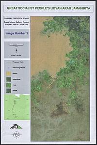
Trans Sahara Railway project
114.
Twenty years of change on the Massachusetts coastline : maps and statistics, 1951-1971
115.
The United States of America circa 1900
116.
U.S. Coast Survey classification and rules for the miscellaneous lettering of names &c. on the map, not connected with title or...
117.
VOC contamination and public water supplies in the commonwealth of Massachusetts
118.
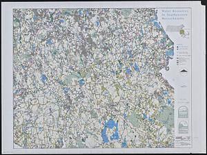
Water resources in southeastern Massachusetts
119.
Whale chart
120.
The Wilderness
« Previous
Next »
1
2
3
4
5
6
7
Limit your search
Subject
Gloucester (Mass.)--Maps
23
Massachusetts--Maps
19
United States--History--Civil War, 1861-1865--Maps
10
Essex County (Mass.)--Maps
7
Land use--Massachusetts--Maps
7
Massachusetts
7
Virginia--History--Civil War, 1861-1865--Maps
7
Coastal
6
more
Subject
»
Place
North and Central America
106
United States
104
Massachusetts
73
Essex (county)
28
Gloucester
20
Virginia
13
Boston
9
Suffolk (county)
9
more
Place
»
Format
Maps/Atlases
118
Books
4
Ephemera
2
Documents
1
Posters
1
Available to use
No known restrictions
105
Date
View distribution
Current results range from
1822
to
2015
Date range begin
Date range end
View larger »
Collection
Norman B. Leventhal Map & Education Center Collection
105
David Judkins Weaver Papers
96
Boston and New England Maps (Collection of Distinction)
67
Urban Maps (Collection of Distinction)
13
Historic Maps
8
Massachusetts Board of Harbor and Land Commissioners
4
Massachusetts Real Estate Atlases
4
Institution
Boston Public Library
105
Salem State University Archives and Special Collections
8
State Library of Massachusetts
8