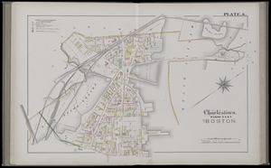
4121. City atlas of Boston, Massachusetts : complete in one volume : from official records, private plans and actual surveys : plate 11 Creator: Hopkins, Griffith Morgan, Jr. Format: Maps/Atlases Collection: Boston and New England Maps (Collection of Distinction) / Norman B. Leventhal Map & Education Center Collection / Urban Maps (Collection of Distinction) Date: 1882 Institution: Boston Public Library
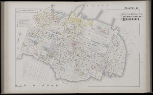
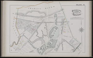
4122. City atlas of Boston, Massachusetts : complete in one volume : from official records, private plans and actual surveys : plate 12 Creator: Hopkins, Griffith Morgan, Jr. Format: Maps/Atlases Collection: Boston and New England Maps (Collection of Distinction) / Norman B. Leventhal Map & Education Center Collection / Urban Maps (Collection of Distinction) Date: 1882 Institution: Boston Public Library
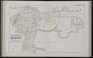
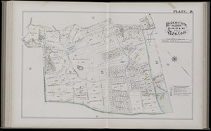
4123. City atlas of Boston, Massachusetts : complete in one volume : from official records, private plans and actual surveys : plate 6 Creator: Hopkins, Griffith Morgan, Jr. Format: Maps/Atlases Collection: Boston and New England Maps (Collection of Distinction) / Norman B. Leventhal Map & Education Center Collection / Urban Maps (Collection of Distinction) Date: 1882 Institution: Boston Public Library
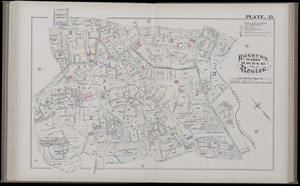
4124. City atlas of Boston, Massachusetts : complete in one volume : from official records, private plans and actual surveys : plate 15 Creator: Hopkins, Griffith Morgan, Jr. Format: Maps/Atlases Collection: Boston and New England Maps (Collection of Distinction) / Norman B. Leventhal Map & Education Center Collection / Urban Maps (Collection of Distinction) Date: 1882 Institution: Boston Public Library
4125. City atlas of Boston, Massachusetts : complete in one volume : from official records, private plans and actual surveys : plate 16 Creator: Hopkins, Griffith Morgan, Jr. Format: Maps/Atlases Collection: Boston and New England Maps (Collection of Distinction) / Norman B. Leventhal Map & Education Center Collection / Urban Maps (Collection of Distinction) Date: 1882 Institution: Boston Public Library
4126. City atlas of Boston, Massachusetts : complete in one volume : from official records, private plans and actual surveys : plate 17 Creator: Hopkins, Griffith Morgan, Jr. Format: Maps/Atlases Collection: Boston and New England Maps (Collection of Distinction) / Norman B. Leventhal Map & Education Center Collection / Urban Maps (Collection of Distinction) Date: 1882 Institution: Boston Public Library
4127. City atlas of Lawrence, Massachusetts : from official records, private plans and actual surveys, based upon plans deposited in the Department of Surveys Creator: Hopkins, Griffith Morgan, Jr., Bromley, George Washington, and Hopkins, H. W. (Henry Whitmer), 1838-1920 Format: Maps/Atlases Collection: Boston and New England Maps (Collection of Distinction) / Norman B. Leventhal Map & Education Center Collection / Urban Maps (Collection of Distinction) Date: 1875 Institution: Boston Public Library
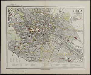
4128. City of Berlin Creator: Letts, Son & Co. Format: Maps/Atlases Collection: Norman B. Leventhal Map & Education Center Collection / Urban Maps (Collection of Distinction) Date: [1878] Institution: Boston Public Library
4129. The city of Binghamton, Broome Co., N.Y : as extended May 19th, 1908 Creator: Westcott, J. R. Format: Maps/Atlases Collection: Norman B. Leventhal Map & Education Center Collection Date: [1919] Institution: Boston Public Library
4130. The city of Boston : 1879 Creator: Hazen, J. C. Format: Maps/Atlases; Manuscripts Collection: Boston and New England Maps (Collection of Distinction) / Norman B. Leventhal Map & Education Center Collection / Urban Maps (Collection of Distinction) Date: 1879 Institution: Boston Public Library
4131. City of Boston Creator: Boston Redevelopment Authority Format: Maps/Atlases Collection: Boston Redevelopment Authority Collection / Boston and New England Maps (Collection of Distinction) / Norman B. Leventhal Map & Education Center Collection / Urban Maps (Collection of Distinction) Date: [1981] Institution: Boston Public Library
4132. City of Boston : topographic and planimetric survey Creator: Boston Redevelopment Authority, Lockwood, Kessler & Bartlett, and Fairchild Aerial Surveys, inc. Format: Maps/Atlases Collection: Boston and New England Maps (Collection of Distinction) / Norman B. Leventhal Map & Education Center Collection / Urban Maps (Collection of Distinction) Date: 1962 Institution: Boston Public Library
4133. The City of Boston : 1879 Creator: O.H. Bailey & Co, O.H. Bailey & Co, and Armstrong & Co. (Boston, Mass.) Format: Maps/Atlases Collection: Boston and New England Maps (Collection of Distinction) / Norman B. Leventhal Map & Education Center Collection / Urban Maps (Collection of Distinction) Date: 1879 Institution: Boston Public Library
4134. The City of Boston : 1879 Creator: O.H. Bailey & Co, O.H. Bailey & Co, and Armstrong & Co. (Boston, Mass.) Format: Maps/Atlases Collection: Boston and New England Maps (Collection of Distinction) / Norman B. Leventhal Map & Education Center Collection / Urban Maps (Collection of Distinction) Date: 1879 Institution: Boston Public Library
4135. The city of Boston Creator: Parsons & Atwater Format: Maps/Atlases Collection: Boston and New England Maps (Collection of Distinction) / Norman B. Leventhal Map & Education Center Collection / Urban Maps (Collection of Distinction) Date: 1873 Institution: Boston Public Library
4136. City of Boston Granary Burying Ground : Boston proper Creator: Jackson, William, 1848-1910; Boston (Mass.). Cemetery Department Format: Maps/Atlases Collection: Boston and New England Maps (Collection of Distinction) / Norman B. Leventhal Map & Education Center Collection Date: [1902] Institution: Boston Public Library
4137. City of Boston improved sewerage : plan showing location of main and secondary intercepting sewers Format: Maps/Atlases Collection: Boston and New England Maps (Collection of Distinction) / Norman B. Leventhal Map & Education Center Collection / Urban Maps (Collection of Distinction) Date: [1877] Institution: Boston Public Library
4138. City of Boston improved sewerage : plan showing region drained by, and lines of proposed intercepting sewer, also course of sewer from proposed reservoirs 1877 Format: Maps/Atlases Collection: Boston and New England Maps (Collection of Distinction) / Norman B. Leventhal Map & Education Center Collection / Urban Maps (Collection of Distinction) Date: [1877] Institution: Boston Public Library
4139. City of Boston plan of Columbia Road, showing connection with Franklin Park and Marine Park : under chapter 394 acts of 1897 Creator: Olmsted, Frederick Law, 1822-1903 Format: Maps/Atlases Collection: Boston and New England Maps (Collection of Distinction) / Norman B. Leventhal Map & Education Center Collection / Urban Maps (Collection of Distinction) Date: 1897 Institution: Boston Public Library
4140. City of Boston topographic and planimetric survey : [Downtown and North End] Creator: Boston Redevelopment Authority Format: Maps/Atlases Collection: Boston Redevelopment Authority Collection / Boston and New England Maps (Collection of Distinction) / Norman B. Leventhal Map & Education Center Collection / Urban Maps (Collection of Distinction) Date: [1960–1969] Institution: Boston Public Library