1. J.H. Colton's Topographical map of seat of war in Virginia, Maryland, &c Creator: Colton, J. H. (Joseph Hutchins), 1800-1893 Format: Maps/Atlases Collection: Norman B. Leventhal Map & Education Center Collection Date: [1864?] Institution: Boston Public Library
2. Bacon's Map of the seat of war in Virginia : showing minutely the interesting localities in the vicinity of Richmond Creator: Bacon & Co Format: Maps/Atlases Collection: Norman B. Leventhal Map & Education Center Collection Date: 1862 Institution: Boston Public Library
3. Bacon's new army map of the seat of war in Virginia, showing the battle fields, fortifications, etc., on & near the Potomac River Creator: Bacon & Co Format: Maps/Atlases Collection: Norman B. Leventhal Map & Education Center Collection Date: 1862 Institution: Boston Public Library
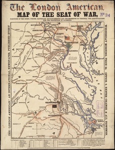
4. Bacon's topographical war map showing the battle fields of Pennsylvania, Maryland, and Virginia Creator: G.W. Bacon & Co Format: Maps/Atlases Collection: Norman B. Leventhal Map & Education Center Collection Date: [1860–1869] Institution: Boston Public Library
5. Central Virginia showing Lieut. Gen'l. U.S. Grant's Campaign and marches of the armies under his command in 1864-65 Creator: United States. Army. Corps of Engineers Format: Maps/Atlases Collection: Norman B. Leventhal Map & Education Center Collection Date: [1865?] Institution: Boston Public Library
6. Diagram of the Battle of Ball's Bluff Format: Maps/Atlases Collection: Norman B. Leventhal Map & Education Center Collection Date: 1861 Institution: Boston Public Library
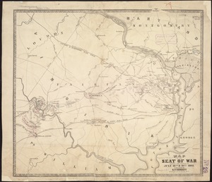
7. E. & G.W. Blunt's corrected map of the seat of war near Richmond, July 10th, 1862 Creator: E. & G.W. Blunt (Firm) Format: Maps/Atlases Collection: Norman B. Leventhal Map & Education Center Collection Date: [1862] Institution: Boston Public Library
8. Field of operations of the Army of the Potomac Format: Maps/Atlases Collection: Norman B. Leventhal Map & Education Center Collection Date: [1862] Institution: Boston Public Library
9. The locality of the great struggle Format: Maps/Atlases Collection: Norman B. Leventhal Map & Education Center Collection Date: 1862 Institution: Boston Public Library
10. Map of n. eastern Virginia and vicinity of Washington Creator: United States. Army. Corps of Topographical Engineers, McDowell, Irvin, 1818-1885, and Schedler, J. (Joseph) Format: Maps/Atlases Collection: Norman B. Leventhal Map & Education Center Collection Date: [1862] Institution: Boston Public Library
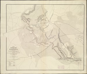
11. Map of the battle fields of the Wilderness May 5th, 6th, and 7th, 1864 : showing the field of operations of the Army of the Potomac commanded by Maj. Gen. George G. Meade Creator: Howell, C. W. Format: Maps/Atlases Collection: Norman B. Leventhal Map & Education Center Collection Date: [1864?] Institution: Boston Public Library
12. Map of the seat of war, positions of the rebel forces, batteries, entrenchments, and encampments in Virginia-the fortifications for the protection of Richmond Format: Maps/Atlases Collection: Norman B. Leventhal Map & Education Center Collection Date: [1861] Institution: Boston Public Library
13. Map of the seat of war showing the battles of July 18th & 21st 1861 Creator: Corbett, V. P. Format: Maps/Atlases Collection: Norman B. Leventhal Map & Education Center Collection Date: 1861 Institution: Boston Public Library
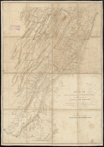
14. Map of the Shenandoah & Upper Potomac including portions of Virginia and Maryland Creator: Meigs, John Rodgers, 1842-1864 Format: Maps/Atlases Collection: Norman B. Leventhal Map & Education Center Collection Date: 1864 Institution: Boston Public Library
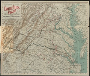
15. Map showing the location of battle fields of Virginia Creator: Chesapeake and Ohio Railway Company Format: Maps/Atlases Collection: Norman B. Leventhal Map & Education Center Collection Date: [ca. 1892] Institution: Boston Public Library
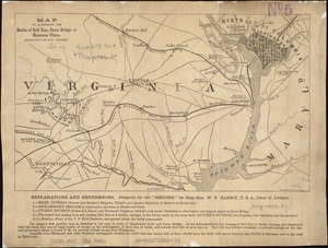
16. Map to illustrate the battle of Bull Run, Stone Bridge or Manassas Plains Format: Maps/Atlases Collection: Norman B. Leventhal Map & Education Center Collection Date: [1862] Institution: Boston Public Library
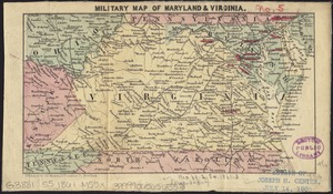
17. Military map of Maryland & Virginia Format: Maps/Atlases Collection: Norman B. Leventhal Map & Education Center Collection Date: [1860–1869] Institution: Boston Public Library
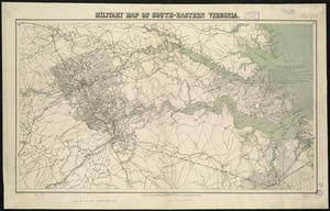
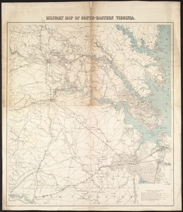
18. Military map of south-eastern Virginia Creator: Lindenkohl, A. Format: Maps/Atlases Collection: Norman B. Leventhal Map & Education Center Collection Date: [1862?] Institution: Boston Public Library
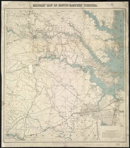
19. Military map of south-eastern Virginia Creator: U.S. Coast and Geodetic Survey Format: Maps/Atlases Collection: Norman B. Leventhal Map & Education Center Collection Date: [1862?] Institution: Boston Public Library
20. Military map of south-eastern Virginia Creator: U.S. Coast and Geodetic Survey, Lindenkohl, A., Lindenkohl, H. (Henry), Krebs, Charles G., and Hawley, Joseph R. (Joseph Roswell), 1826-1905 Format: Maps/Atlases Collection: Norman B. Leventhal Map & Education Center Collection Date: [1862?] Institution: Boston Public Library