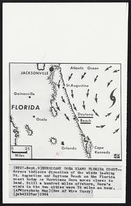
101. Hurricane Dora Slams Florida Coast--Arrows indicate direction of the winds lashing St. Augustine and Daytona Beach on the Florida coast today as Hurricane Dora moves... Creator: Associated Press Format: Photographs Collection: Boston Herald-Traveler Photo Morgue Date: [ca. September 1964] Institution: Boston Public Library
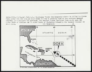
102. Hurricane "Dora," the dangerous sister to killer hurricane Cleo, aimed its 115 mile an hour winds 9/3 for a glancing blow at the northern Leeward islands. In a... Creator: United Press International Format: Photographs Collection: Boston Herald-Traveler Photo Morgue Date: [ca. September 1964] Institution: Boston Public Library
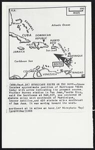
103. Hurricane Edith on the Move--Cross locates approximate position of Hurricane Edith today with arrow indicating its present course. Weather Bureau station in San Juan,... Creator: Associated Press Format: Photographs Collection: Boston Herald-Traveler Photo Morgue Date: [ca. September 1963] Institution: Boston Public Library
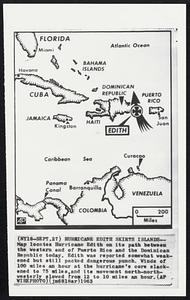
104. Hurricane Edith Skirts Islands--Map locates Hurricane Edith on its path between the western end of Puerto Rico and the Dominican Republic today. Edith was reported... Creator: Associated Press Format: Photographs Collection: Boston Herald-Traveler Photo Morgue Date: [ca. September 1963] Institution: Boston Public Library
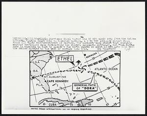
105. Hurricane Ethel turned its 95 MPH winds away from the twice-battered Florida coast 9/11 to threaten Bermuda. A 5 PM EST advisory placed Ethel about 235 miles... Creator: United Press International Format: Photographs Collection: Boston Herald-Traveler Photo Morgue Date: [ca. September 1964] Institution: Boston Public Library
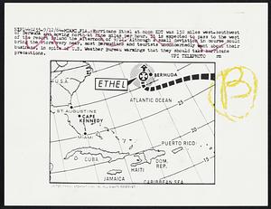
106. Hurricane Ether at noon EDT was 150 miles west-southwest of Bermuda and moving north at nine miles per hour. It is expected to pass to the west of the resort island... Creator: United Press International Format: Photographs Collection: Boston Herald-Traveler Photo Morgue Date: [ca. September 1964] Institution: Boston Public Library
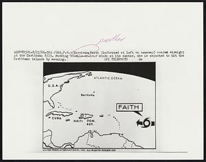
107. Hurricane Faith (indicated at left on newsmap) headed straight at the Caribbean 8/25. Packing 90-mile-an-hour winds at its center, she is expected to hit the Caribbean... Creator: United Press International Format: Photographs Collection: Boston Herald-Traveler Photo Morgue Date: [ca. August 1966] Institution: Boston Public Library
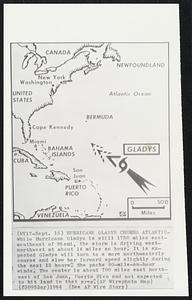
108. Hurricane Gladys Churns Atlantic-While Hurricane Gladys is still 1750 miles east-southeast of Miami, the storm is driving west-northwest at about 14 miles an hour. It... Creator: Associated Press Format: Photographs Collection: Boston Herald-Traveler Photo Morgue Date: [ca. September 1964] Institution: Boston Public Library
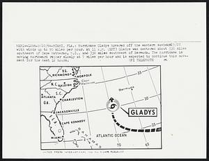
109. Hurricane Gladys hovered off the eastern seaboard 9/20 with winds up to 90 miles per hour. At 11 A.M. (EST) Gladys was centered about 550 miles southeast of Cape... Creator: United Press International Format: Photographs Collection: Boston Herald-Traveler Photo Morgue Date: [ca. September 1964] Institution: Boston Public Library
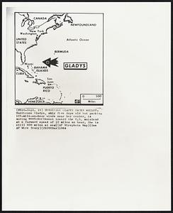
110. Hurricane Gladys Packs Wallop- Hurricane Gladys, only five days old but packing 125-mile-an-hour winds near her center, is moving west-northwest toward the U.S.,... Creator: Associated Press Format: Photographs Collection: Boston Herald-Traveler Photo Morgue Date: [ca. September 1964] Institution: Boston Public Library
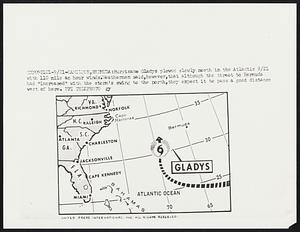
111. Hurricane Gladys slowly north in the Atlantic 9/21 with 110 mile an hour winds. Weathermen said, however, that although the threat to Bermuda had "increased" with the... Creator: United Press International Format: Photographs Collection: Boston Herald-Traveler Photo Morgue Date: [ca. September 1964] Institution: Boston Public Library
112. Hurricane Hazel Heads Northward--Solid arrow locates route of Hurricane Hazel with broken arrow indicating its expected course as it moves northward at 30 to 35 miles... Creator: Associated Press Format: Photographs Collection: Boston Herald-Traveler Photo Morgue Date: [ca. October 1954] Institution: Boston Public Library
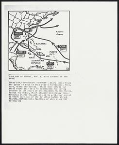
113. Hurricane ‘Highway’--Heavy lines trace the paths of four of this year’s hurricanes, Cleo, Dora, Hilda, and Isbell. There were others but these especially will be... Creator: Associated Press Format: Photographs Collection: Boston Herald-Traveler Photo Morgue Date: [ca. November 1964] Institution: Boston Public Library
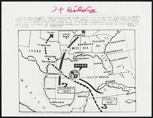
114. Hurricane Hilda built up to a “severe” blow with 125-mile-an-hour winds 10/1 and slowly headed for the low-lying Louisiana coast.At noon,EDT,the storm was centered... Creator: United Press International Format: Photographs Collection: Boston Herald-Traveler Photo Morgue Date: [ca. October 1964] Institution: Boston Public Library
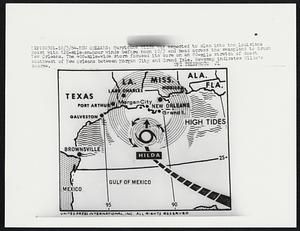
115. Hurricane Hilda Heads for Louisiana With 130-mile-an-hour winds in the center, hurricane Hilda tonight is bearing down on the Louisiana coast from which more than... Creator: Associated Press Format: Photographs Collection: Boston Herald-Traveler Photo Morgue Date: [ca. October 1964] Institution: Boston Public Library
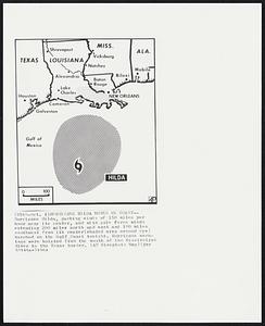
116. Hurricane Hilda Moves on Coast-- Hurricane Hilda, packing winds of 150 miles per hour near its center, and with gale force winds extending 200 miles north and east and... Creator: Associated Press Format: Photographs Collection: Boston Herald-Traveler Photo Morgue Date: [ca. October 1964] Institution: Boston Public Library
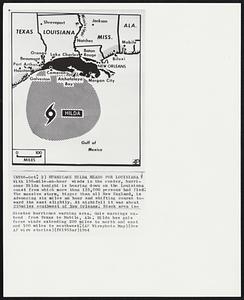
117. Hurricane Hilda was expected to slam into the Louisiana coast with 120-mile-an-hour winds before noon 10/3 and head across the swampland to brush New Orleans. The... Creator: United Press International Format: Photographs Collection: Boston Herald-Traveler Photo Morgue Date: [ca. October 1964] Institution: Boston Public Library
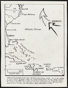
118. Hurricane Hits Bermuda--Hurricane winds up to 100 miles an hour struck Bermuda today as a hurricane (black arrow) swept north-westward from Atlantic, aimed in general... Creator: Associated Press Format: Photographs Collection: Boston Herald-Traveler Photo Morgue Date: [ca. September 1948] Institution: Boston Public Library
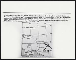
119. Hurricane hunters located 8/21 a tropical disturbance far out in the Atlantic and forecasters promptly named it Cleo, although it has not yet attained storm... Creator: United Press International Format: Photographs Collection: Boston Herald-Traveler Photo Morgue Date: [ca. August 1964] Institution: Boston Public Library
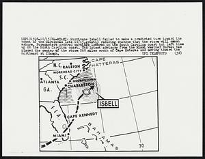
120. Hurricane Isbell failed to make a predicted turn toward the coast of the Carolinas late 10/15,greatly reducing chances that the storm will smash ashore. Forecasters... Creator: United Press International Format: Photographs Collection: Boston Herald-Traveler Photo Morgue Date: [ca. November 1964] Institution: Boston Public Library