Skip to search
Skip to main content
Skip to first result
Digital Commonwealth
Folders
Sign Up / Log In
Search for
Search
Search
Search
Basic
Advanced
Explore
Map
Collections
Institutions
Formats
For Educators
Primary Source Sets
Lesson Plans
Using Primary Sources
Searching Digital Commonwealth
For Institutions
Join Digital Commonwealth
Conferences, Trainings, & Events
How to Contribute Collections
Digitization Services
Board & Committees
Frequently Asked Questions
About
About Digital Commonwealth
News & Announcements
Copyright & Terms of Use
Harmful Content Statement
Partners
API
Contact Us
Search
Search Constraints
Start Over
Save Search
Your search:
More Like
commonwealth:m326rf15z
✖
Remove constraint More Like: commonwealth:m326rf15z
« Prev. |
1
-
20
of
96
|
Next »
Sort
by relevance
relevance
title
date (asc)
date (desc)
recently added
Number of results to display per page
20
per page
per page
10
per page
20
per page
50
per page
100
per page
View results as:
List
list view
Maps
map view
Gallery
grid view
Search Results
1.
The 1976 proposed regional open space plan
2.
Airbrush base for the Pelorus Linea region of Europa
3.
Aitoff's equal area projection of the sphere
4.
Antietam
5.
Appomattox Court House
6.
Azimuthal map projections
7.
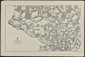
Bermuda Hundred
8.
Black in New England 1840
9.
Boston bikemap : toward intelligent commuting
10.
Boston's bikemap : Arlington, Belmont, Brookline, Cambridge, Chelsea, Everett, Lexington, Malden, Medford, Needham, Newton,...
11.
Buffers around tributaries to the Wachusett Reservoir compared to 1985 urban landuse and currently protected open space in...
12.
Cape Cod
13.
Cape Cod open space : SCORP-GIS integration project
14.
Chancellorville
15.
[Character conversion print errors on] Draft working map Neponset River estuary
16.
Chesapeake Bay, environmentally sensitive areas
17.
Cold Harbor
18.
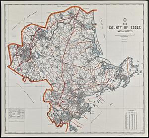
The county of Essex, Massachusetts
19.
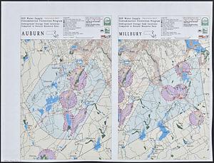
DEP water supply contamination correction program underground storage tank locations compared to natural resource data : Auburn...
20.
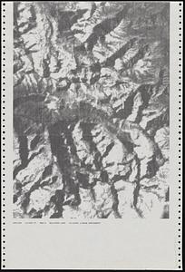
Dot matrix printouts of Landsat satellite images
« Previous
Next »
1
2
3
4
5
Limit your search
Subject
Massachusetts--Maps
17
United States--History--Civil War, 1861-1865--Maps
10
Land use--Massachusetts--Maps
7
Virginia--History--Civil War, 1861-1865--Maps
7
Connecticut--Maps
5
Watersheds--Massachusetts--Maps
5
Boston Metropolitan Area (Mass.)--Maps
4
Open spaces--Massachusetts--Maps
4
more
Subject
»
Place
North and Central America
81
United States
80
Massachusetts
51
Virginia
13
Boston
8
Suffolk (county)
8
Connecticut
5
Essex (county)
4
more
Place
»
Format
Maps/Atlases
93
Ephemera
2
Documents
1
Posters
1
Available to use
No known restrictions
96
Date
View distribution
Current results range from
1867
to
2015
Date range begin
Date range end
View larger »
Collection
David Judkins Weaver Papers
96
Norman B. Leventhal Map & Education Center Collection
96
Boston and New England Maps (Collection of Distinction)
60
Urban Maps (Collection of Distinction)
7
Institution
Boston Public Library
96


![[Character conversion print errors on] Draft working map Neponset River estuary](https://bpldcassets.blob.core.windows.net/derivatives/images/commonwealth:mc87v2589/image_thumbnail_300.jpg)